“I like anything DIY… it makes me feel more self-sufficient, which in turn gives me a sense of self-reliance: I just love knowing “I could make that if I need to”.”

This, was indeed a joyous summer, endowed not only with delightful weather but with the visit of the Public Lab to London. Between August and September this year we planned and deployed five free-of-charge and fully hands-on initiatives of public engagement and in the spirit of discovering, understanding the world in our own terms, and DIY prototyping, we met 28 wonderful people whose experience I briefly share here.
The first initiative took place on Parliament Hill, within Hampstead Heath. Through learning by doing we introduced DIY aerial photography using kites. Over the course of the afternoon members of the public learned about the applications of kite mapping as we shared stories and they perused one of the Grassroots Mapping Forum editions. We got kites up in the air, waited for a steady flight and then attached the picavet with the camera on continuous shooting to the kite line. In pairs we walked around the heath to capture a larger area, attracting the attention of park visitors. Some asked “How high does it go?” “What will you do with the pictures – will they be publicly available?” “I’ve lived here for over 50 years and would love to see what the Heath looks like from above*“.
I asked the kite-mappers what had attracted them to this event in the first place. One of them answered “I had never tried it before and I wanted to see how “homemade google maps” would work out.“
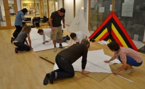
The second initiative took place in Islington, at the Mildmay Community Centre (MCC). “Oh my god! We’re going to make kites that big?” Mathew Lippincott from Public Lab has a love for kites – their playfulness, the culture that flying them incites, their mechanics – something he transmitted through his enthusiasm throughout the 3.5 hour delta kite-making workshop. All the materials to make these large kites can be locally-sourced and the materials are affordable, rendering them very cheap DIY tools for environmental monitoring as well: kite materials £10-15 plus line & spool £20-45. Matthew is very hands off and so with our sleeves rolled up we learnt that this technique is fully DIY and transferable as we started to teach and learn from each other. One kite maker said “I loved it! it wasn’t just a kite, it was my kite!” and he felt incredibly proud of his new found ability to Do-It-Himself.
The third initiative also took place at the MCC and involved flying delta kites for capturing aerial photography. We began with a recap on kite-making by Shannon Dosemagen from Public Lab and then an explanation of the DIY equipment and techniques: camera rigs/holders, kite line, camera setup (setting up continuous shooting, attachment to rig). From the MCC we took a short walk to Clissold Park in Hackney, where we would actually fly the kites. We couldn’t wait! Matthew shared with us his experiences of flying kites, and we learnt about safety – for our hands, passers by, and our cameras! The weather seemed to have paused the showers just so we could have our perfect moment. The sun was shining beautifully and the intermittent winds gave us the opportunity to learn (the hard way) how to get our kites up in the air. We flew the kites for about 25 minutes and the whole outing was just over an hour.
We now headed back excited to see our pictures. At the MCC’s IT room we got our turn to do some “DIY google maps”, as one kite-mapper put it. Through the stories Matthew and Shannon shared we learnt about the uses of maps made from composite aerial imagery just like the one we had captured at Clissold Park. We were introduced to the open-source online software MapKnitter.org. We downloaded the photographs from the two cameras we flew in the park and began selecting, learning to understand, intuitively, air-photo interpretation. We began asking questions, wondering, making sense of the world in a different way. MapKnitter is intuitive and allows users to upload their aerial photographs to overlay them on Google Maps. Not all the pictures we take using kite-mapping are perpendicular to the ground but MapKnitter solve this issue; the software enables you to adjust, rotate, and distort the images in a semi-transparent layer to fit with recognisable landmarks on Google Maps. In our later discussion of application of this DIY technique in their everyday life some shared their thoughts with me: “hmm, quite frankly, i can’t quite see how kite mapping could be useful for me personally. But if the opportunity comes in the future, now I will surely know a solution!” “It could be valuable in my work with human rights organisations around the world as a documentation tool. It could also be used for advocacy campaigns, as in “the result is not interesting”, but as in “we can monitor you”.” and “It empower us to document our communities, events, create evidence when issues are contested”
…to be continued!
*The map for Hampstead Heath will be available soon on the Grassroots Mapping Forum website.

Reblogged this on dropitintheocean and commented:
I have been interested in citizen science for several years, so I am very excited to have just discovered this blog! I will return and read more soon!